No matter where they are located or how much they cost, the most elegant property development projects all have one thing in common - a deep understanding of the topographic features of the land that is being developed. This understanding allows the developer, architect and builder to best utilize existing features for both aesthetic and economic value, as well as proactively deal with the basic concerns of drainage issues, potential storm water runoff and flooding.
What is a Topographic Survey
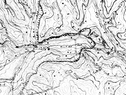
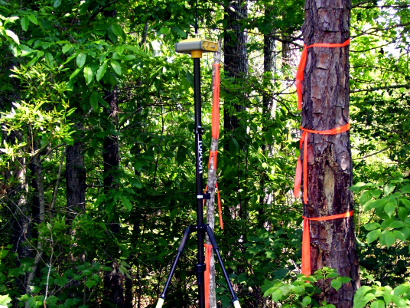
To create a topographic land survey, special instruments are used to record both horizontal and vertical information at specific points on the property. These recorded values are gathered by skilled topographic land surveyors who use precise instruments to capture each measurement.
Once gathered, these values provide the information necessary to create a grid view of the property that enables the surveyor to accurately calculate contours in each section of the grid. Once the entire grid is completed it will form a topographic view of the entire property that will accurately illustrate both natural and man-made features of the land including depressions, ditches, streams, rivers, roadways, excavated areas, etc.
The resulting grids form completed topographical surveys that can be utilized in both print and digital forms. These topographic surveys assist property developers, architects, building contractors, landscapers and owners so that any issues can be dealt with before or during actual construction, when it will be most cost effective to do so.
Topographic Surveying Enhances Visual Aspects
In addition to helping property developers counteract issues with terrain or drainage, topographical surveying can also help enhance visual aspects of the property. For example, a housing development might utilize the information provided by a topographical survey to ensure that the view is maximized for each home that will be constructed on the property.
Topographical Survey Costs Vary by Area
Because no two parcels of land are the same, no two topographical surveys will be the same. Terrain that is extremely rugged or steep can be much more difficult for the surveyor's team to traverse in order to gather the measurements required to create the grid.
Your local survey professional, however, can use their knowledge of the area to estimate the approximate topographic survey cost for you. In addition, they will be able to answer any specific questions you may have about how the actual values are taken and how the grid is created, as well as offering helpful ideas on dealing with terrain issues common to your specific area.